Contact Seller
London Fine Antiques
Tel02071833511or07889 725 975Please quote Antiques Atlas.

 Antique Framed Buckinghamshire Map, English, 17thC
 Antique Framed St Christopher & Nevis Map, English
 Antique South America Map, English, Cartography
 Vintage Middlesex County Map, English, Framed
 Vintage County Map, Middlesex, English, Framed
 Vintage Western Australia Map, Framed Tallis Print
 Antique Road Map, London to Hythe, Kent, English
 Antique County Map, Cornwall, Kernow, English
 1889 Descriptive Map of London Poverty by C. Booth
 Original Camden/Norden Map of Middlesex & London
 Robert Morden Map of Wiltshire, c.1695
 Robert Morden Map of Cumberland (Cumbria), c.1695
Non UK callers :
+44 2071833511
or +44 7889 725 975
or +44 7889 725 975
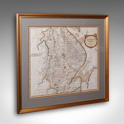
Antique Lincolnshire Map, English, Cartography


Our Stock # 25626
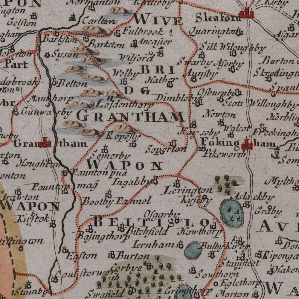
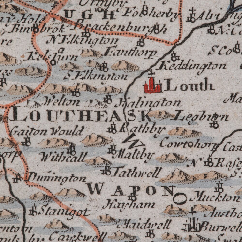
This is a fine antique county map of Lincolnshire. An English, framed reproduction engraving, dating to the Victorian period and later, circa 1900.
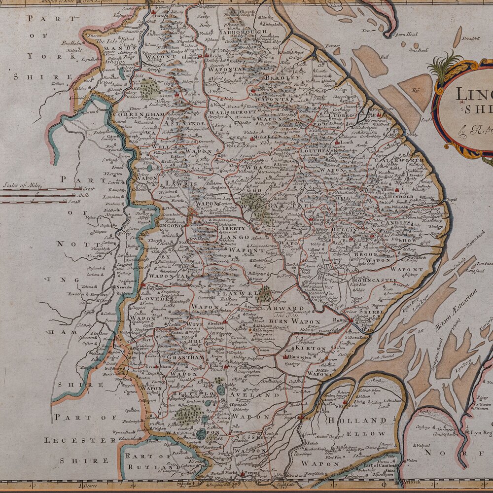
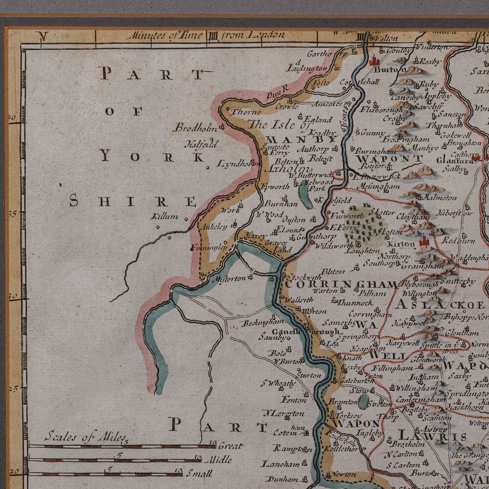
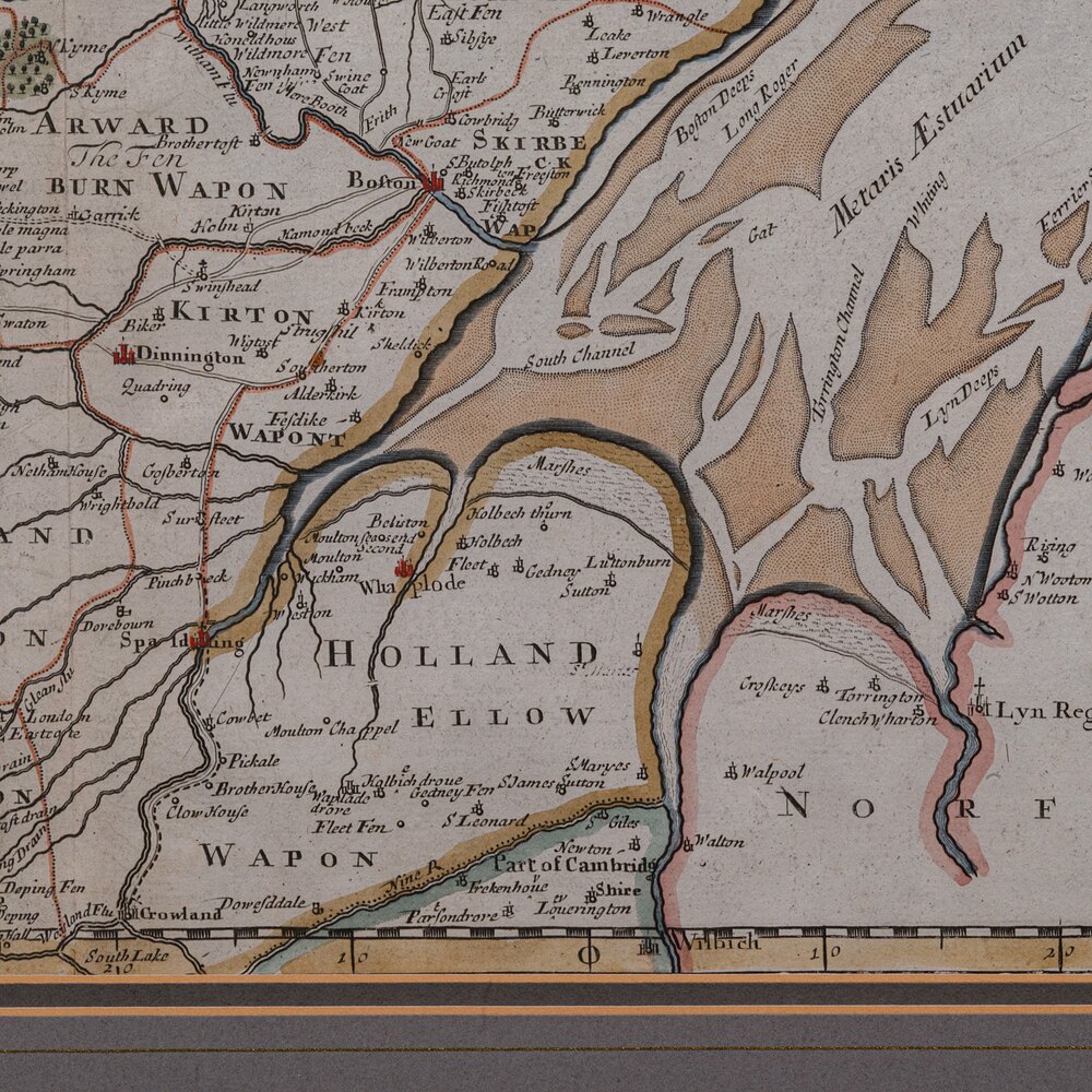
A superb cartographic reproduction originally charted by Robert Morden in the late 17th century. With its hand-coloured detailing and charming aged appearance, this piece makes a wonderful display for the study, hallway, or library.
Faithful county cartography reproduction, capturing a historic period of Lincolnshire
Originally charted by Robert Morden, one of England’s most esteemed early mapmakers
Displays a desirable aged patina and remains in good order throughout
Presented behind clear glass within a tasteful later glazed frame
Fascinating level of cartographic detail, illustrating administrative regions, rivers, and historic towns
Displays Wapon Taks - an alternative form of Wapentake, the county equivalent of political Hundreds
Fine detail given to The Wash, the tidal estuary between Lincolnshire and Norfolk
Hand coloured palette accentuates borders and settlements with period accuracy
Dressed to the rear with a hanging braid, ensuring ease of display upon arrival
This is a charming antique map of Lincolnshire, beautifully presented and steeped in geographic and historic interest, offering an elegant addition to any period interior or collector’s wall. Delivered ready to display, ideal for collectors of antique maps or English county history
Dimensions:
Max Width: 55cm (21.75'')
Max Depth: 2.5cm (1'')
Max Height: 50cm (19.75'')
Map Width: 41.5cm (16.25'')
Map Height: 35.5cm (14'')
We offer a 100% satisfaction guarantee with all of our antiques.
We ship worldwide with professional packing and attractive rates – please send us your post / zip code and country for a quote.
Free delivery to most of the U.K. – Please send us your post code for confirmation.
Deliveries taking on average ten working days to arrive at your door from receipt of payment.
Please contact us if you require any further information - we are here to help.
Our Ref: 25626 Free delivery to most of the. U. K. & fast worldwide shipping
SellerLondon Fine Antiques
View all stock from
London Fine Antiques

 Unit 4B
Courtlands Trading Estate
Taunton
Somerset
TA2 6NS
Tel : 02071833511
or : 07889 725 975
Non UK callers : +44 2071833511 or +44 7889 725 975
Get directions to London Fine Antiques
This is a fine antique county map of Lincolnshire. An English, framed reproduction engraving, dating to the Victorian period and later, circa 1900.
A superb cartographic reproduction originally charted by Robert Morden in the late 17th century. With its hand-coloured detailing and charming aged appearance, this piece makes a wonderful display for the study, hallway, or library.
Faithful county cartography reproduction, capturing a historic period of Lincolnshire
Originally charted by Robert Morden, one of England’s most esteemed early mapmakers
Displays a desirable aged patina and remains in good order throughout
Presented behind clear glass within a tasteful later glazed frame
Fascinating level of cartographic detail, illustrating administrative regions, rivers, and historic towns
Displays Wapon Taks - an alternative form of Wapentake, the county equivalent of political Hundreds
Fine detail given to The Wash, the tidal estuary between Lincolnshire and Norfolk
Hand coloured palette accentuates borders and settlements with period accuracy
Dressed to the rear with a hanging braid, ensuring ease of display upon arrival
This is a charming antique map of Lincolnshire, beautifully presented and steeped in geographic and historic interest, offering an elegant addition to any period interior or collector’s wall. Delivered ready to display, ideal for collectors of antique maps or English county history
Dimensions:
Max Width: 55cm (21.75'')
Max Depth: 2.5cm (1'')
Max Height: 50cm (19.75'')
Map Width: 41.5cm (16.25'')
Map Height: 35.5cm (14'')
We offer a 100% satisfaction guarantee with all of our antiques.
We ship worldwide with professional packing and attractive rates – please send us your post / zip code and country for a quote.
Free delivery to most of the U.K. – Please send us your post code for confirmation.
Deliveries taking on average ten working days to arrive at your door from receipt of payment.
Please contact us if you require any further information - we are here to help.
Our Ref: 25626 Free delivery to most of the. U. K. & fast worldwide shipping
Price
Arrange a final price and delivery details directly with the dealer
Click here to message the seller The price has been listed in British Pounds.
Conversion rates as of 2/DEC/2025. Euro & Dollar prices will vary and should only be used as a guide.
Always confirm final price with dealer.
Category Antique Ephemera
Date c.1900
1900s Antiques Material Paper
Origin English
Item code as272a8818 / 25626
Status For Sale
£685.00 
$904.27
€779.12

$904.27

€779.12

Looking to Buy?
Payment with PayPal is availableArrange a final price and delivery details directly with the dealer
Click here to message the seller

Conversion rates as of 2/DEC/2025. Euro & Dollar prices will vary and should only be used as a guide.
Always confirm final price with dealer.
View all stock from
London Fine Antiques

 Unit 4B
Courtlands Trading Estate
Taunton
Somerset
TA2 6NS
Tel : 02071833511
or : 07889 725 975
Non UK callers : +44 2071833511 or +44 7889 725 975
Get directions to London Fine Antiques
You may also be interested in
 Antique Framed Buckinghamshire Map, English, 17thC
 Antique Framed St Christopher & Nevis Map, English
 Antique South America Map, English, Cartography
 Vintage Middlesex County Map, English, Framed
 Vintage County Map, Middlesex, English, Framed
 Vintage Western Australia Map, Framed Tallis Print
 Antique Road Map, London to Hythe, Kent, English
 Antique County Map, Cornwall, Kernow, English
 1889 Descriptive Map of London Poverty by C. Booth
 Original Camden/Norden Map of Middlesex & London
 Robert Morden Map of Wiltshire, c.1695
 Robert Morden Map of Cumberland (Cumbria), c.1695

Websites for Antiques Dealers
Promote your stock and business
Read our testimonials
Read our testimonials