Contact Seller
London Fine Antiques
Tel02071833511or07889 725 975Please quote Antiques Atlas.

 Vintage Western Australia Map, Framed Tallis Print
 Antique Road Map, London to Hythe, Kent, English
 Antique County Map, Cornwall, Kernow, English
 1889 Descriptive Map of London Poverty by C. Booth
 Original Camden/Norden Map of Middlesex & London
 Robert Morden Map of Wiltshire, c.1695
 Robert Morden Map of Cumberland (Cumbria), c.1695
 Robert Morden Map of Cumberland (Cumbria), c.1695
 Jan Jansson Map of Cumbria & Westmoria c.1646
 Antique County Map, Cheshire, English, Framed
 Vintage County Map of Cheshire, English, John Cary
 Vintage County Map, Kent, Historic Cartography
Non UK callers :
+44 2071833511
or +44 7889 725 975
or +44 7889 725 975
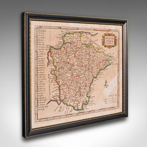
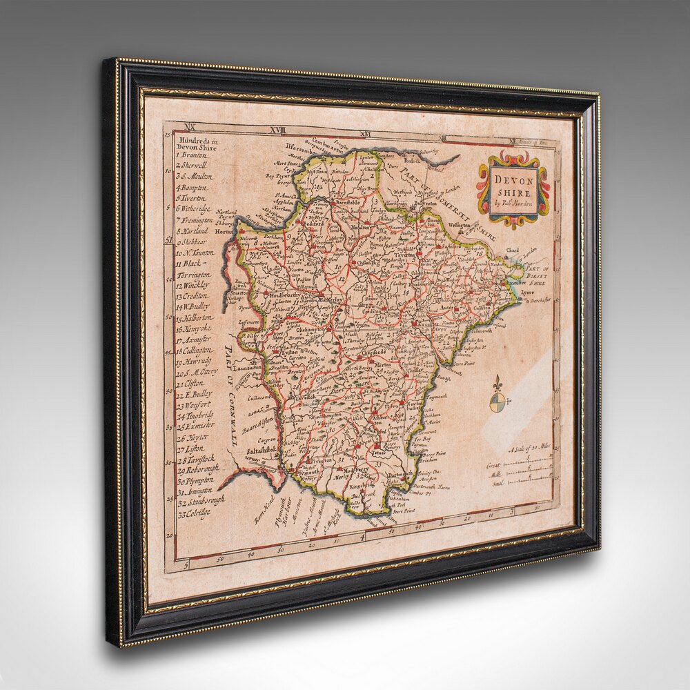
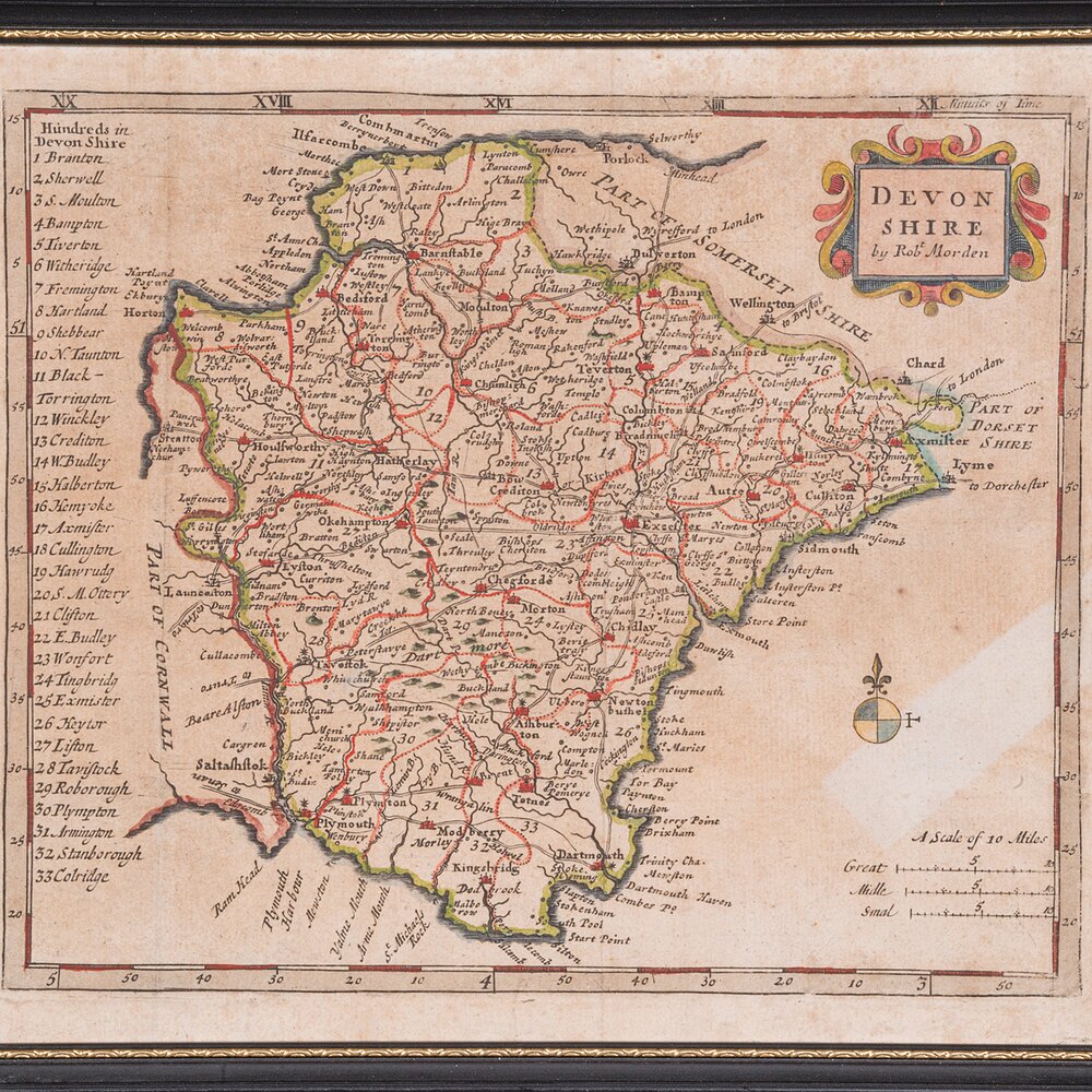
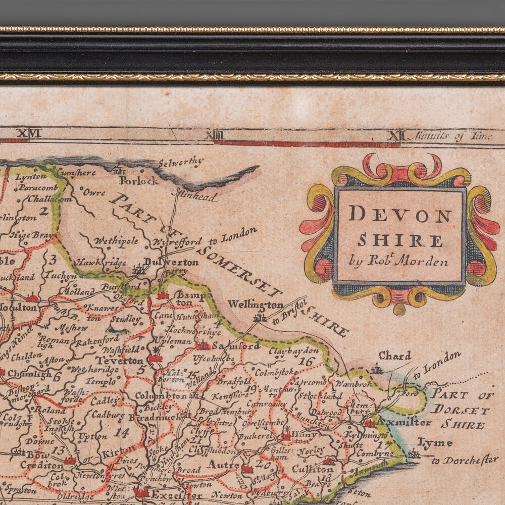
Antique Devonshire Map, English Framed, Devon


Our Stock # 25486
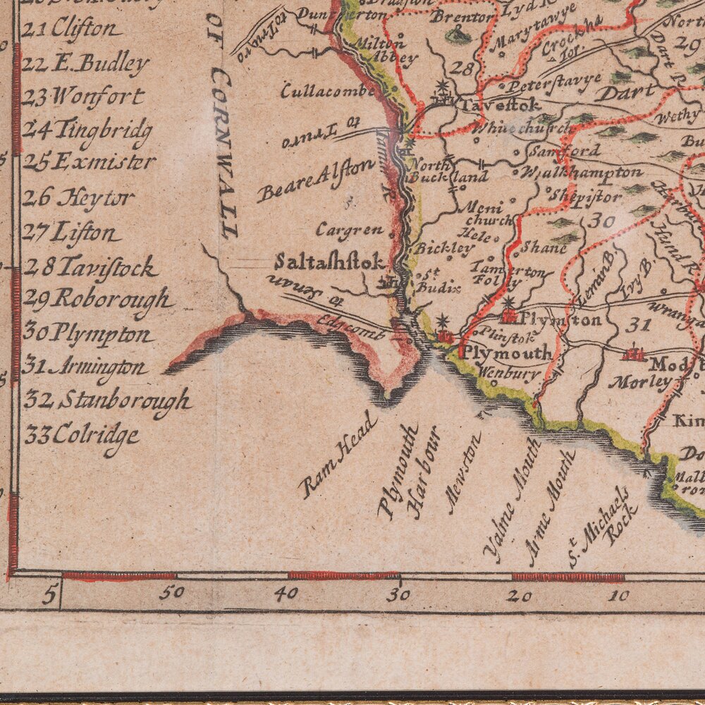
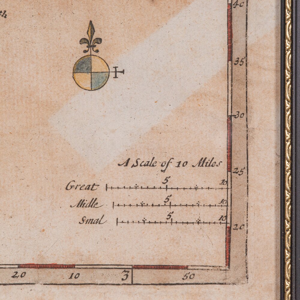
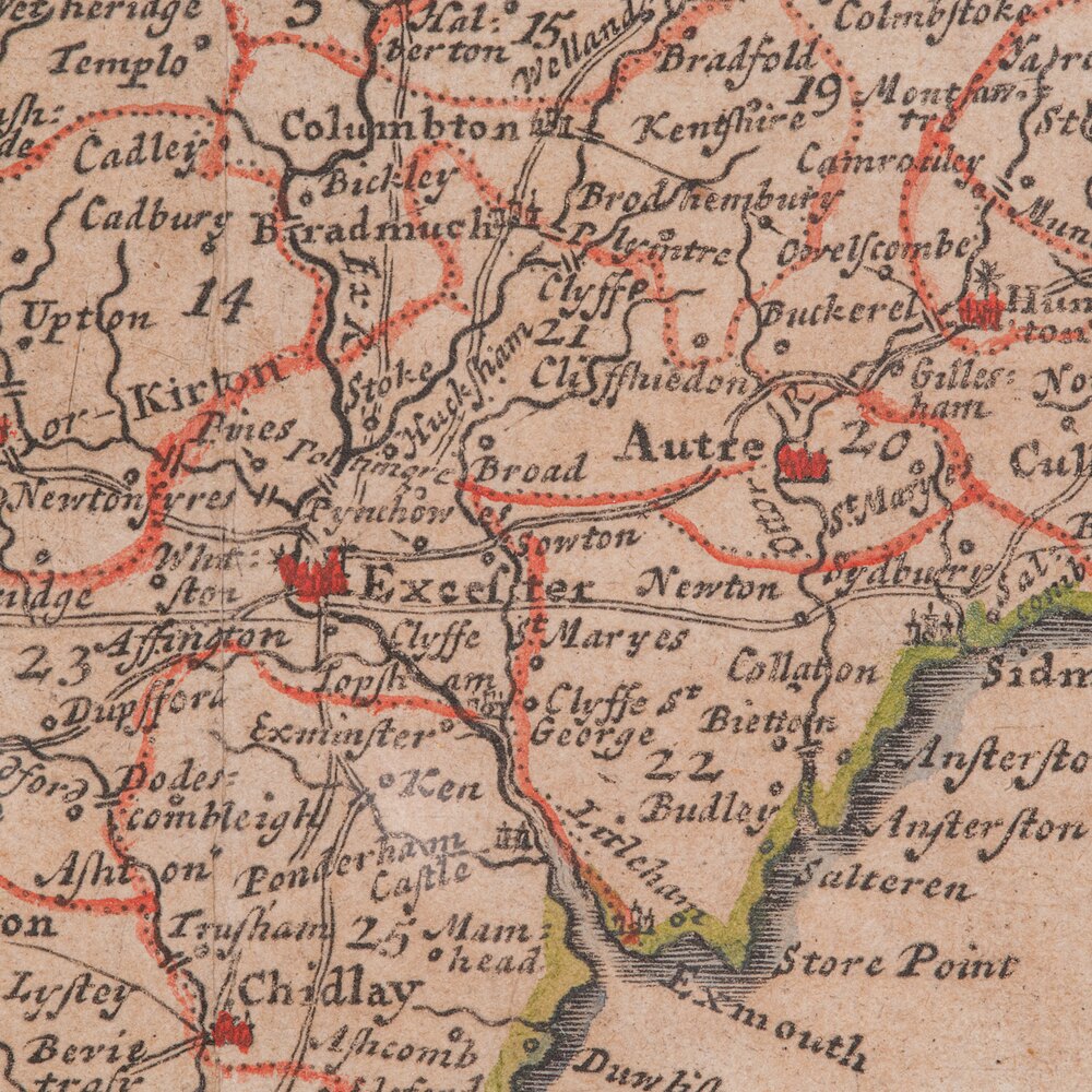
This is a small antique map of Devonshire, an English framed cartographic engraving by Robert Morden, dating to the early Georgian period, circa 1720. A charming and historically rich representation of the county, this hand-coloured engraving captures the elegance of early 18th century mapmaking.
Fascinating 18th century map of Devon, brimming with historic detail and charm
Posthumous reproduction of Robert Morden’s celebrated work, as published in Magna Britannia by Thomas Cox, 1720
Engraved cartography displays the administrative Hundreds and antique spellings of familiar towns and regions
Hand coloured accents enrich the visual appeal, with delicate tonality throughout
Presented in a tasteful later frame, offering sympathetic enhancement to the period character
Glazed with clear glass, protecting the map while ensuring excellent clarity
Dressed to the rear with mounting wire, ready for immediate wall hanging
A wonderful piece for collectors of early British cartography, or those with a fondness for Devonshire heritage
This small antique county map is a delightful and informative decorative piece, steeped in early Georgian geography. An ideal addition to the traditional study, country house interior, or heritage gallery wall. Delivered ready to display.
Dimensions:
Max Width: 25cm (9.75'')
Max Depth: 1cm (.5'')
Max Height: 22cm (8.75'')
Map Width: 22cm (8.75'')
Map Height: 19cm (7.5'')
We offer a 100% satisfaction guarantee with all of our antiques.
We ship worldwide with professional packing and attractive rates – please send us your post / zip code and country for a quote.
Free delivery to most of the U.K. – Please send us your post code for confirmation.
Deliveries taking on average ten working days to arrive at your door from receipt of payment.
Please contact us if you require any further information - we are here to help.
Our Ref: 25486 Free delivery to most of the. U. K. & fast worldwide shipping
SellerLondon Fine Antiques
View all stock from
London Fine Antiques

 Unit 4B
Courtlands Trading Estate
Taunton
Somerset
TA2 6NS
Tel : 02071833511
or : 07889 725 975
Non UK callers : +44 2071833511 or +44 7889 725 975
Get directions to London Fine Antiques
This is a small antique map of Devonshire, an English framed cartographic engraving by Robert Morden, dating to the early Georgian period, circa 1720. A charming and historically rich representation of the county, this hand-coloured engraving captures the elegance of early 18th century mapmaking.
Fascinating 18th century map of Devon, brimming with historic detail and charm
Posthumous reproduction of Robert Morden’s celebrated work, as published in Magna Britannia by Thomas Cox, 1720
Engraved cartography displays the administrative Hundreds and antique spellings of familiar towns and regions
Hand coloured accents enrich the visual appeal, with delicate tonality throughout
Presented in a tasteful later frame, offering sympathetic enhancement to the period character
Glazed with clear glass, protecting the map while ensuring excellent clarity
Dressed to the rear with mounting wire, ready for immediate wall hanging
A wonderful piece for collectors of early British cartography, or those with a fondness for Devonshire heritage
This small antique county map is a delightful and informative decorative piece, steeped in early Georgian geography. An ideal addition to the traditional study, country house interior, or heritage gallery wall. Delivered ready to display.
Dimensions:
Max Width: 25cm (9.75'')
Max Depth: 1cm (.5'')
Max Height: 22cm (8.75'')
Map Width: 22cm (8.75'')
Map Height: 19cm (7.5'')
We offer a 100% satisfaction guarantee with all of our antiques.
We ship worldwide with professional packing and attractive rates – please send us your post / zip code and country for a quote.
Free delivery to most of the U.K. – Please send us your post code for confirmation.
Deliveries taking on average ten working days to arrive at your door from receipt of payment.
Please contact us if you require any further information - we are here to help.
Our Ref: 25486 Free delivery to most of the. U. K. & fast worldwide shipping
Price
Arrange a final price and delivery details directly with the dealer
Click here to message the seller The price has been listed in British Pounds.
Conversion rates as of 3/DEC/2025. Euro & Dollar prices will vary and should only be used as a guide.
Always confirm final price with dealer.
Category Antique Ephemera
Date c.1720
Georgian Antiques Material Paper
Origin English
Item code as272a8582 / 25486
Status For Sale
£495.00 
$659.88
€565.98

$659.88

€565.98

Looking to Buy?
Payment with PayPal is availableArrange a final price and delivery details directly with the dealer
Click here to message the seller

Conversion rates as of 3/DEC/2025. Euro & Dollar prices will vary and should only be used as a guide.
Always confirm final price with dealer.
View all stock from
London Fine Antiques

 Unit 4B
Courtlands Trading Estate
Taunton
Somerset
TA2 6NS
Tel : 02071833511
or : 07889 725 975
Non UK callers : +44 2071833511 or +44 7889 725 975
Get directions to London Fine Antiques
You may also be interested in
 Vintage Western Australia Map, Framed Tallis Print
 Antique Road Map, London to Hythe, Kent, English
 Antique County Map, Cornwall, Kernow, English
 1889 Descriptive Map of London Poverty by C. Booth
 Original Camden/Norden Map of Middlesex & London
 Robert Morden Map of Wiltshire, c.1695
 Robert Morden Map of Cumberland (Cumbria), c.1695
 Robert Morden Map of Cumberland (Cumbria), c.1695
 Jan Jansson Map of Cumbria & Westmoria c.1646
 Antique County Map, Cheshire, English, Framed
 Vintage County Map of Cheshire, English, John Cary
 Vintage County Map, Kent, Historic Cartography

Websites for Antiques Dealers
Promote your stock and business
Read our testimonials
Read our testimonials