Contact Seller
London Fine Antiques
Tel02071833511or07889 725 975Please quote Antiques Atlas.

 Antique Devon County Map, English, Framed, 17th.C
 Antique Framed Cornwall Map, English, Cartography
 Antique Framed Gloucestershire Map, English Atlas
 John Cary Hand-Coloured Original Map of Sussex
 Old World Map Linen Backed
 Antique Map of Asia, French, Framed, Atlas, C.1800
 John Cary Early 19th Century Framed Map 1816
 Antique Jamaica Map, English, Caribbean, 1790
 Antique Suffolk County Map, Dutch, Atlas Novus
 Antique Gloucestershire Map, Atlas, English
 Antique Gloucestershire Map, English, Framed
 Antique Map of Bohemia, Dutch, Framed Cartography
Non UK callers :
+44 2071833511
or +44 7889 725 975
or +44 7889 725 975
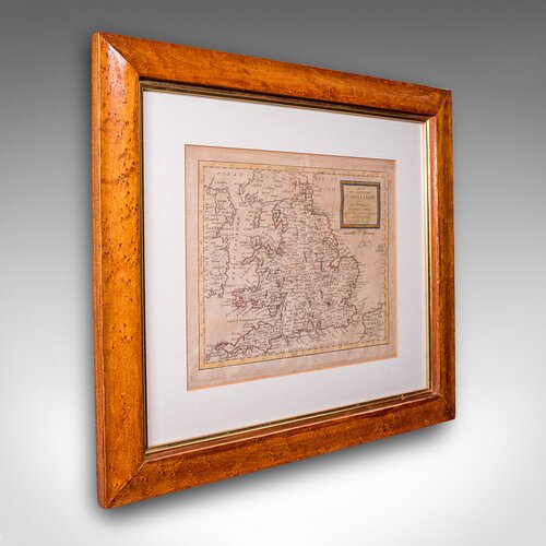
Antique Map of England & Wales, French, Framed


Our Stock # 25965
This is an antique map of England. A French, maple framed cartography engraving by Jean-Baptiste Nolin, this posthumous atlas edition dating to the Georgian period, circa 1780.
Full Title: Carte Du Royaume D'Angleterre, divise par Provinces, Schires ou Comtés, suivant les dernieres observations Par J.B. Nolin, géographe du Rei.
A precisely detailed, early 18th century map of England and Wales, rich in historical and decorative appeal
Presents a desirable aged patina and presented in gently time worn order
Displayed within a tasteful maple frame offering clear protective glazing
Dressed to the rear with hanging wire for ease of display
Jean-Baptiste Nolin (1657-1708) was a successful map maker in the late 17th century
Later atlas edition published posthumously by his eponymous son
Detailed engraving with period place names and annotated in French
Wonderful decorative and informative interest for the Irish or a collector
This is a fascinating late 18th century England map, a delightful atlas engraving published by the cartographer's son. Perfect for collectors of antique maps and national history. Delivered ready to display.
Dimensions:
Max Width: 47.5cm (18.75'')
Max Depth: 2.5cm (1'')
Max Height: 42.5cm (16.75'')
Map Width: 28.5cm (11.25'')
Map Height: 23.5cm (9.25'')
We offer a 100% satisfaction guarantee with all of our antiques.
We ship worldwide with professional packing and attractive rates – please send us your post / zip code and country for a quote.
Free delivery to most of the U.K. – Please send us your post code for confirmation.
Deliveries taking on average ten working days to arrive at your door from receipt of payment.
Please contact us if you require any further information - we are here to help.
Our Ref: 25965 Free delivery to most of the. U. K. & fast worldwide shipping
SellerLondon Fine Antiques
View all stock from
London Fine Antiques

 Unit 4B
Courtlands Trading Estate
Taunton
Somerset
TA2 6NS
Tel : 02071833511
or : 07889 725 975
Non UK callers : +44 2071833511 or +44 7889 725 975
Get directions to London Fine Antiques
This is an antique map of England. A French, maple framed cartography engraving by Jean-Baptiste Nolin, this posthumous atlas edition dating to the Georgian period, circa 1780.
Full Title: Carte Du Royaume D'Angleterre, divise par Provinces, Schires ou Comtés, suivant les dernieres observations Par J.B. Nolin, géographe du Rei.
A precisely detailed, early 18th century map of England and Wales, rich in historical and decorative appeal
Presents a desirable aged patina and presented in gently time worn order
Displayed within a tasteful maple frame offering clear protective glazing
Dressed to the rear with hanging wire for ease of display
Jean-Baptiste Nolin (1657-1708) was a successful map maker in the late 17th century
Later atlas edition published posthumously by his eponymous son
Detailed engraving with period place names and annotated in French
Wonderful decorative and informative interest for the Irish or a collector
This is a fascinating late 18th century England map, a delightful atlas engraving published by the cartographer's son. Perfect for collectors of antique maps and national history. Delivered ready to display.
Dimensions:
Max Width: 47.5cm (18.75'')
Max Depth: 2.5cm (1'')
Max Height: 42.5cm (16.75'')
Map Width: 28.5cm (11.25'')
Map Height: 23.5cm (9.25'')
We offer a 100% satisfaction guarantee with all of our antiques.
We ship worldwide with professional packing and attractive rates – please send us your post / zip code and country for a quote.
Free delivery to most of the U.K. – Please send us your post code for confirmation.
Deliveries taking on average ten working days to arrive at your door from receipt of payment.
Please contact us if you require any further information - we are here to help.
Our Ref: 25965 Free delivery to most of the. U. K. & fast worldwide shipping
Price
Arrange a final price and delivery details directly with the dealer
Click here to message the seller The price has been listed in British Pounds.
Conversion rates as of 20/MAY/2026. Euro & Dollar prices will vary and should only be used as a guide.
Always confirm final price with dealer.
Category Antique Ephemera
Date c.1780
George III Antiques Material Paper
Origin French
Item code as272a9176 / 25965
Status For Sale
£845.00 
$1135.09
€976.99

$1135.09

€976.99

Looking to Buy?
Payment with PayPal is availableArrange a final price and delivery details directly with the dealer
Click here to message the seller

Conversion rates as of 20/MAY/2026. Euro & Dollar prices will vary and should only be used as a guide.
Always confirm final price with dealer.
View all stock from
London Fine Antiques

 Unit 4B
Courtlands Trading Estate
Taunton
Somerset
TA2 6NS
Tel : 02071833511
or : 07889 725 975
Non UK callers : +44 2071833511 or +44 7889 725 975
Get directions to London Fine Antiques
You may also be interested in
 Antique Devon County Map, English, Framed, 17th.C
 Antique Framed Cornwall Map, English, Cartography
 Antique Framed Gloucestershire Map, English Atlas
 John Cary Hand-Coloured Original Map of Sussex
 Old World Map Linen Backed
 Antique Map of Asia, French, Framed, Atlas, C.1800
 John Cary Early 19th Century Framed Map 1816
 Antique Jamaica Map, English, Caribbean, 1790
 Antique Suffolk County Map, Dutch, Atlas Novus
 Antique Gloucestershire Map, Atlas, English
 Antique Gloucestershire Map, English, Framed
 Antique Map of Bohemia, Dutch, Framed Cartography